Chinese government remains silent on the topic
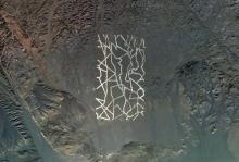
How did conspiracies ever thrive before Google Maps? The latest global oddity spotted by Google's all-seeing eye is a series of shapes in the Gobi Desert of China. Most people agree that the shapes were created by scraping off a layer of topsoil, thus providing visual contrast between the surface soil and the layer below. (Note: this is also how the Nazca Lines are formed. Just putting that out there.)
But what the shapes mean and who put them there is still up for debate. Their location is considered significant. The shapes are in the remote northwestern quadrant of China which is dedicated to military and space technology. It's essentially China's Area 51.
The shapes, which are clustered in an area about 20 miles across, are about a mile wide. Many feel they are "clearly meant to be seen from space." But I have to point out that, with current Earth technology, so is a car's license plate.
Why build something so large and relatively crude to test satellite guidance systems (as one theory claims)? It's particularly preposterous to claim that they are for calibrating spy satellites. If your spy satellites need a calibration grid a mile wide, then you need to get yourself some better spy satellites.
Some particularly fevered online conspiracy theorists are trying to match up the gridlines with American cities, in the belief that these are mock cities that China is using for wargame practice.
But the pragmatics counter with the simple fact that China literally owns us, and if they wanted to destroy America, all they would have to do is call in their debt. (And why bomb the cities of the country that owes you trillions of dollars? You'll never get that money back if you flatten their infrastructure!)
A historian consulted by the New York Times points out that there is no fence around the shapes, which (to him) indicates a lack of strategic importance. But I think we can assume that the Gobi Desert itself serves as a fence, both in its inhospitable climate, extreme remote location, and in the lack of cover it provides for anyone trying to sneak out onto the range.
The Chinese government has so far declined to comment. (No surprise there.) The leading theory currently on the table is that the shapes have been used for bombing practice. Indeed, at least two of the areas appear to have a lot of charred and exploded "stuff" in them. I guess if I was in charge of something as vast and barren as the Gobi Desert, I would probably spend a lot of time blowing stuff up there, too!
